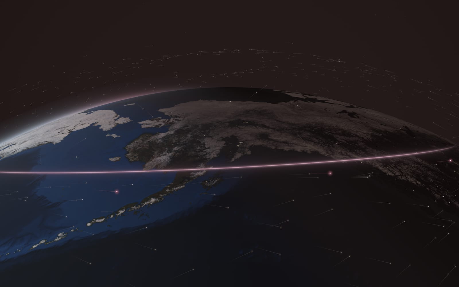
Southeast Alaska, Kodiak and the Aleutians fall inside or near the edge; nearly everyone else is outside it. If you live in Alaska and need internet soon, Amazon Leo is not a realistic option to wait for. The buy-or-wait tool walks through what to do instead.
What the FCC said
When the FCC approved Amazon's first-generation system in 2020, it noted the gap plainly and waived its rule that a system like this must cover all 50 states:
“Given the proposed design of the Kuiper system, service cannot be provided to the majority of Alaska.”
FCC 20-102, Order and Authorization, released · Confirmed · checked
Amazon's own 2019 technical filing put it more bluntly: “Alaska’s high latitude makes it effectively impossible to serve using the Kuiper System.” Nothing Amazon has published since names Alaska. Its newer statements promise “initial latitude bands” without saying which Announced.
Why the line falls near 58.7°N
It comes down to two numbers in Amazon's own filings.
- How far north the satellites fly. Every Leo satellite launched so far goes to Amazon's 630 km shell, and its FCC license sets that shell's orbits at a tilt of 51.9° to the equator. So none ever passes over a point farther north than 51.9°N.
- How low a dish will look. Amazon's filing says its terminals only talk to satellites at least 35° above the horizon. A satellite at the top of its path is still that high in the sky for a dish about 470 miles farther north, but no farther.
- Add them up. That reach is about 6.8° of latitude, so the edge sits near 58.7°N Our calculation (the drawing below shows it to scale). North of it, no satellite in today's shell ever climbs 35° above your horizon.
- The edge is not the coverage line. Near the edge a satellite passes only now and then. Amazon's own filing promised continuous coverage only to about 56°N Announced.
Drawn to scale
Why the first Leo satellites stop short of most of Alaska
A slice through the Earth along a line of longitude, from 49°N to 62°N, with heights and distances to scale. A Leo satellite's path tops out over 51.9°N at about 630 km up. A dish at 58.7°N sees that satellite exactly 35° above its horizon, the lowest angle Amazon's terminals use. North of 58.7°N no satellite in this shell ever climbs that high. Amazon's own filing promised continuous coverage only to about 56°N.
Amazon's other first-generation shells are tilted less, so they reach even less of the north. Only the 51.9° shell gets past 48.62°N:
| Shell | Tilt (inclination) | Farthest north at 35° minimum |
|---|---|---|
| 590 km | 30°Confirmedchecked | 36.43°NOur calculationchecked |
| 590 km | 33°Confirmedchecked | 39.43°NOur calculationchecked |
| 610 km | 42°Confirmedchecked | 48.62°NOur calculationchecked |
| 630 km | 51.9°Confirmedchecked | 58.7°NOur calculationchecked |
Our calculation from the shells in the FCC's Feb 10, 2026 grant and the 35° minimum in Amazon's 2019 filing. The higher minimum Amazon lists for low-gain links moves each edge a little farther south.
Where the edge falls on the map
Draw the line across the state and the picture is stark. Southern Southeast Alaska and the Aleutians sit inside the band Amazon filed; Juneau and Kodiak sit between that band and the edge, so expect part-time service at best unless Amazon says otherwise; Anchorage, the Mat-Su, the Kenai Peninsula, Fairbanks and every town farther north are outside.
Computed view
How far north each network reaches, computed from orbital data
- South of ~56°N: inside Amazon's filed continuous-coverage band
- ~56°N to 58.7°N: reachable on paper, part-time at best
- North of 58.7°N: beyond the edge of today's satellites
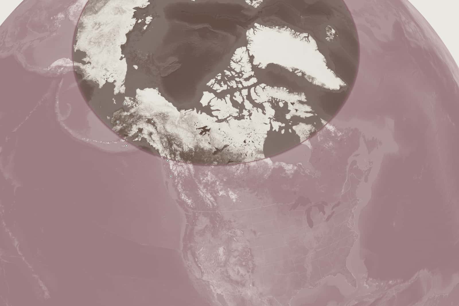
- Utqiagvik, 71.3°N: Beyond the edge
- Fairbanks, 64.8°N: Beyond the edge
- Nome, 64.5°N: Beyond the edge
- Anchorage, 61.2°N: Beyond the edge
- Bethel, 60.8°N: Beyond the edge
- Juneau, 58.3°N: Inside the edge, part-time at best
- Kodiak, 57.8°N: Inside the edge, part-time at best
- Ketchikan, 55.3°N: Inside the filed continuous band
Map drawn by us
A closer look: where the edge crosses Alaska
- South of ~56°N: inside Amazon's filed continuous-coverage band
- ~56°N to 58.7°N: reachable on paper, part-time at best
- North of 58.7°N: beyond the edge of today's satellites
- Utqiagvik 71.3°N: Beyond the edge
- Fairbanks 64.8°N: Beyond the edge
- Nome 64.5°N: Beyond the edge
- Anchorage 61.2°N: Beyond the edge
- Bethel 60.8°N: Beyond the edge
- Juneau 58.3°N: Inside the edge, part-time at best
- Kodiak 57.8°N: Inside the edge, part-time at best
- Ketchikan 55.3°N: Inside the filed continuous band
How many Alaskans that leaves out
Counting every 2020 Census block by latitude, 642,646 Our calculation of Alaska's 733,391 residents, about 87.6%, live north of 58.7°N. Use the stricter angle Amazon lists for low-gain links and the share rises to 92.3%; measured from the 56°N continuous-coverage line, it's 96.3%.
- South of 56°N: 3.7%
- 56°N to 58.7°N: 8.7%
- North of 58.7°N: 87.6% Our calculation
Towns inside and outside the edge
Census places from the same count, largest first, with the latitude of each place's center. The lists come straight from our data file, so they update when it does.
Outside: north of 58.7°N
- Anchorage61.17°N291,247
- Fairbanks64.84°N32,515
- Knik-Fairview61.51°N19,297
- Badger64.80°N19,031
- College64.87°N11,332
- North Lakes61.62°N9,450
- Meadow Lakes61.64°N9,197
- Wasilla61.58°N9,054
- Tanaina61.66°N8,817
- Kalifornsky60.45°N8,487
- Kenai60.56°N7,424
- Steele Creek64.93°N6,437
47 more places
- Bethel60.79°N6,325
- Chena Ridge64.79°N6,015
- Sterling60.54°N5,918
- Palmer61.60°N5,888
- Gateway61.57°N5,748
- Homer59.65°N5,522
- South Lakes61.59°N5,229
- Fishhook61.73°N5,048
- Utqiagvik71.25°N4,927
- Farmers Loop64.91°N4,704
- Nikiski60.73°N4,456
- Soldotna60.48°N4,342
- Valdez61.08°N3,985
- Big Lake61.52°N3,833
- Nome64.51°N3,699
- Butte61.53°N3,589
- Goldstream64.94°N3,299
- Kotzebue66.88°N3,102
- Farm Loop61.63°N2,747
- Seward60.12°N2,717
- Eielson AFB64.67°N2,610
- Cordova60.53°N2,609
- Ester64.88°N2,416
- Deltana63.79°N2,359
- Dillingham59.06°N2,249
- Fritz Creek59.75°N2,248
- North Pole64.75°N2,243
- Willow61.89°N2,196
- Ridgeway60.53°N2,136
- Bear Creek60.21°N2,129
- Anchor Point59.75°N2,105
- Houston61.62°N1,975
- Point MacKenzie61.34°N1,852
- Haines59.25°N1,657
- Susitna North62.15°N1,564
- Lazy Mountain61.66°N1,506
- Cohoe60.27°N1,471
- Hooper Bay61.51°N1,375
- Diamond Ridge59.70°N1,330
- Prudhoe Bay70.37°N1,310
- Tok63.33°N1,243
- Skagway59.46°N1,164
- Funny River60.48°N1,103
- Salamatof60.60°N1,078
- Talkeetna62.31°N1,055
- Sutton-Alpine61.74°N1,038
- Buffalo Soapstone61.68°N1,021
Inside the edge, north of 56°N
- Juneau58.37°N32,255
- Sitka57.19°N8,458
- Kodiak57.79°N5,581
- Mill Bay57.82°N4,216
- Petersburg56.76°N3,043
- Wrangell56.18°N2,127
- Kodiak Station57.77°N1,673
- Hoonah58.12°N931
- Womens Bay57.69°N743
- Gustavus58.44°N655
- Kake56.98°N543
South of 56°N
- Ketchikan55.36°N8,192
- Unalaska53.91°N4,254
- Akutan54.14°N1,589
- Metlakatla55.12°N1,454
- Craig55.49°N1,036
- King Cove55.09°N757
- Klawock55.56°N720
- Sand Point55.31°N578
Population: 2020 Census. "Inside the band" means the geometry allows it, not that Amazon has said it will serve these towns or when; it hasn't.
The polar system: approved, not launched
What could change the answer is a separate set of satellites on steeply tilted orbits. The FCC approved Amazon's polar system on Feb 10, 2026 Confirmed: 1,292 satellites in three shells (600 km at 82°, 620 km at 66°, 650 km at 80°). The FCC grant records Amazon's own description: “Kuiper has clarified that its three constellations operate independently and serve different geographic regions.”
| Item | Status |
|---|---|
| Approved by the FCC | Feb 10, 2026 Confirmed checked |
| Satellites approved | 1,292 Confirmed checked |
| Polar satellites launched | 0 Confirmed checked |
| Launch date announced | Not announcedchecked |
| FCC deadline: half in orbit | Feb 10, 2032 Confirmed checked |
| FCC deadline: all in orbit | Feb 10, 2035 Confirmed checked |
Those are deadlines, not a schedule: the license lets Amazon take until then. Amazon has also filed for a separate phone-to-satellite system with some high-inclination shells (5,105 satellites; applied to the FCC (2026); deployment planned from 2028 Planned). That one is for phones, not for home internet through a Leo dish.
Alaska coverage: what readers ask
Will Amazon Leo work in Alaska?
Not in most of the state with the satellites Amazon is launching now. They reach about 58.7°N at most Our calculation, and about 87.6% of Alaskans live north of that. Parts of Southeast Alaska, Kodiak and the Aleutians are within reach on paper; Amazon hasn't said when or whether it will serve them.
Will Amazon Leo work in Anchorage?
No, not with today's satellites. Anchorage sits at about 61.2°N, north of the 58.7°N edge Our calculation. The polar layer that could change that has not launched.
Will Amazon Leo work in Fairbanks?
No. Fairbanks, at about 64.8°N, is well beyond the edge of the current satellites' reach Our calculation.
Will Amazon Leo work in Juneau or Ketchikan?
Possibly, but not fully. Ketchikan (about 55.4°N) is inside the band Amazon filed for continuous coverage; Juneau (about 58.4°N) is past that band but inside the edge, so expect part-time service at best Our calculation. Amazon has named no Alaska towns, dates or plans.
Amazon says service starts at northern latitudes. Does that include Alaska?
Amazon said its rollout would begin “in northern and southern latitudes” Announced. With every satellite in the 51.9° shell, “northern” can only mean the upper part of what that shell reaches, which ends near 58.7°N. That reading is ours; Amazon hasn't named any state.
When will Amazon Leo cover Alaska?
Amazon hasn't said. Its polar satellites are approved but none has launched, no launch date is announced, and the FCC's deadline for half of them is Feb 10, 2032 checked .
Does Starlink work in Alaska?
Yes. Starlink's specifications say: Serves Alaska, with higher latency than the lower 48 Confirmed. Speeds there trail the rest of the country in Ookla's tests.
Read next

How these facts were checked
The FCC wording comes from the FCC's 2020 Kuiper order (FCC 20-102) and Amazon's 2019 technical filing. The edge latitude is our own geometry from Amazon's filed orbit (inclination and altitude) and minimum elevation angle, using the standard coverage formula; the share of Alaskans is our count of 2020 Census blocks by latitude. Both are labeled "our calculation". The polar system's details come from the FCC Space Bureau grant of Feb 10, 2026. Read the editorial policy.
FCC orders and Census data files are fixed public records whose text can't change, so the "Facts checked" date leaves them out. We read them on Oct 25, 2026; each one is listed at the foot of the page.
Where each fact comes from
- cdn.geekwire.com/wp-content/uploads/2019/07/Kuiper-Technical.pdf (primary source) · checked
- www2.census.gov/programs-surveys/decennial/2020/data/01-Redistr… (primary source) · checked
- docs.fcc.gov/public/attachments/DA-26-553A1.pdf (primary source) · checked
- aboutamazon.com/news/innovation-at-amazon/project-kuiper-satell… (primary source) · checked
- cdn.geekwire.com/wp-content/uploads/2026/02/AmazonLeo-Gen2.pdf (primary source) · checked
- aboutamazon.com/news/amazon-leo/amazon-leo-direct-to-device-sat… (primary source) · checked
- Starlink spec sheet (DOC-DF-1915-15313-48) (primary source) · checked
- ookla.com/research/reports/us-broadband-performance-report-h1-2… (primary source) · checked
- aboutamazon.com/news/amazon-leo/amazon-leo-arianespace-first-mi… (primary source) · checked
- docs.fcc.gov/public/attachments/FCC-20-102A1.pdf (primary source) · checked
- Natural Earth 1:50m cultural vectors (state outlines, used for our map), Natural Earth (dataset) · checked